|
You
are here: /main/research
expeditions/May-June 2005
NWHI
Maritime Archaeology, Ecosystem Connectivity, Mapping and
Coral Disease Expedition 2005
 From
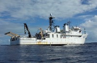
May 14th through June 7th 2005, the NOAA (National Oceanic
and Atmospheric Administration) research vessel Hi`ialakai
("embracing pathways to the sea," pictured to left),
will be conducting a research expedition to the Northwestern
Hawaiian Islands. The expedition includes martime archaeology,
coral disease, multi-beam mapping and ecosystem connectivity
missions. During the expedition, Kelly Gleason, a maritime
archaeology researcher, will be sending updates back from
the vessel. From
May 14th through June 7th 2005, the NOAA (National Oceanic
and Atmospheric Administration) research vessel Hi`ialakai
("embracing pathways to the sea," pictured to left),
will be conducting a research expedition to the Northwestern
Hawaiian Islands. The expedition includes martime archaeology,
coral disease, multi-beam mapping and ecosystem connectivity
missions. During the expedition, Kelly Gleason, a maritime
archaeology researcher, will be sending updates back from
the vessel.
Click
here for other maps of the region
Feature
- Using
Multi-Beam Mapping to determine depth contours (large
image - 403 KB)
Feature
- Mapping an Unnamed Seamount
SE of Pearl and Hermes Atoll
Feature
- Mapping
Brooks Bank 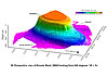
Journal
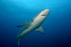
-
Final Day at French Frigate Shoals
and the 14 Foot Tiger Shark
Journal
-
Day Two at Kure Atoll
Journal
-
Day One at Kure Atoll: Reporting from
the Top of the Archipelago
Journal
-
Day
Three at Midway Atoll
Journal
-
Day
Two at Midway Atoll
Journal
-
Day
One at Midway Atoll
Journal
-
Day
Three at Pearl and Hermes Atoll
Journal
-Day
Two at Pearl and Hermes Atoll: More Mapping…
Journal
-
First
Day at Pearl and Hermes Atoll: Investigating Shipwrecks NWHI
Style
Journal
-
Last
Day at French Frigate Shoals
Journal
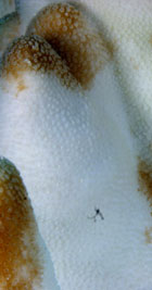
-
Day
2 at French Frigate Shoals: Late night mapping and coral disease
discovery
Journal
-
Day
1 at French Frigate Shoals
|