|
You
are here: /main/research
expeditions/May 2005/Day 1 Pearl
and Hermes
Day
1, Pearl and Hermes Atoll
by Kelly Gleason, Maritime Archaeology Team

We
work up this morning to a grey and drizzly day at Pearl and
Hermes Atoll. You know you’ve been spoiled by these
waters when people are grumbling that they’re cold in
75 degree ocean temperatures. As fish and coral teams headed
out to conduct monitoring and tagging work, this was an especially
exciting day for the maritime archaeology team. Exciting would
actually be an understatement because I know that I speak
for most of the team when I say that we have been anticipating
this trip to Pearl and Hermes Atoll for several months. In
September of 2004, NOAA NMFS Coral Reef Ecosystem Division’s
Debris Removal Team came across the wreckage of a whaling
shipwreck (or shipwrecks) at Pearl and Hermes Atoll. They
reported the wrecksite to Hans Van Tilburg, the maritime heritage
coordinator for the Pacific Islands Regional National Marine
Sanctuary Program, and since last fall, a great deal of time
has gone into preparing for this trip to begin to document
and interpret these wrecks.
Wrecksites
in the Northwestern Hawaiian Islands are unlike those anywhere
else in the world. Just as these waters are pristine and free
of anthropogenic influences for fish and coral, the same is
true for shipwreck sites in the Northwestern Hawaiian Islands.
We are able to document and manage shipwreck sites that have
been preserved by their remote locations, and still contain
valuable evidence of our maritime heritage in this part of
the world. Seeing these shipwrecks reminds us of how valuable
these sites can be as tools for interpreting our past. The
shipwreck site at Pearl and Hermes Atoll is still unidentified,
however, it has been speculated to be the sites of the Pearl
and the Hermes, two British whaling ships that were sailing
in consort to the newly discovered Japan Whaling grounds in
1822. The Pearl ran aground first, and the Hermes made an
attempt to assist and instead ran aground as well. These were
the only two whaling ships reported lost at Pearl and Hermes
Atoll, and so the artifacts discovered on the site last fall
by the debris crew, which included iron trypots (used for
boiling the whale fat), were major clues about the identity
of these sites.
Our
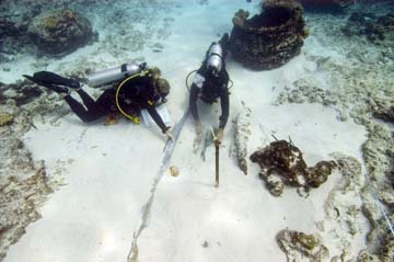
plan for the whaling shipwreck site is to thoroughly map the
site, and establish a strategy for long term monitoring of
the site. One of the first tasks for underwater archaeologists
at a shipwreck site is laying down a baseline, similar to
a transect through the site by which all artifacts and shipwreck
features will be measured off of. Most shipwreck mapping projects
take weeks, and some take months. This site is extensive enough
that we would love to have that kind of time on this site.
However, the nature of an interdisciplinary cruise to these
remote areas has forced us to look at how we will map this
site in a new way since our time is very limited at this atoll.
We have looked to methodology that ecologists use in order
to deal with the logistical challenges in this part of the
world, and have applied a similar strategy by setting permanent
datum points at the shipwreck site for long term monitoring
purposes. Today at the site, we set these points and began
detailed measurements and sketches of major artifacts at the
site. This was an exciting day for the maritime archaeology
team. It is so rare to come across a site so pristine and
untouched. Whaling is a large part of the maritime history
of this region, and to come across such an incredible example
of this history is a reminder of why we’re so lucky
that these heritage resources still exist in these untouched
waters of the Northwestern Hawaiian Islands. The human stories
attached to shipwreck survival and rescue are an exciting
dimension to the significance of all that has transpired in
these waters for hundreds of years.
|