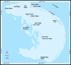
Latest News
Expeditions
For Teachers
For Keiki (Kids)
Discussions
About the Area
Residents
Photo Images
Video Images
Maps and Satellite Images
More Info
Partners

You are here: /main/maps and satellite images/

Maps and Satellite Images

Click here for bathymetry maps.Graphic Maps - these maps depict land formations, bathymetric contours, and some shallow corals. Complements of Christine Taylor of NOAA's National Marine Sanctuary Program.
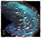
 

Satellite Images - these images are either from the IKONOS satellites or from NASA's LANDSAT 7 (only the image of the banks near French Frigate Shoals, all others are IKONOS). IKONOS images were purchased by NOAA and LANDSAT were purchased by the U.S. Geological Survey. Image processing was performed by Kris Holderied of NOAA.

Bathymetric Atlas of the Northwestern Hawaiian Islands

Habitat Mapping in the NWHI

Large map of the Papahanaumokuakea Marine National Monument

Large Map of Northwestern and Main Hawaiian Islands ( 1.1 MB)

National Geographic Map of the Hawaiian Archipelago

Map 1 of NWHI Coral Reef Ecosystem Reserve on top of the continental United States (for comparison of size)

Map 2 of NWHI Coral Reef Ecosystem Reserve on top of the continental United States (different version for comparison of size)

Coral Reefs and Mangroves of the World

Distances from the NWHI to Various Places around the Pacific


Home | News | About | Expeditions | Photos | Video | Maps
Discussions | Partners | Teachers | Keiki | More Info | Search
Contact Us | Privacy Policy
This site is hosted by the
Laboratory for Interactive Learning Technologies
at the University of Hawai`i