Talk About It!
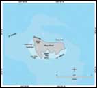
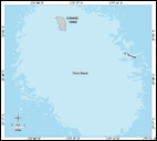
Necker's chart location
Asked by Roger on Jan 23, 2004.
The map of Necker Island as shown on your website indicates it is between 23 deg 44 min and 23 deg 45 min latitude. Everything else I can find (via NOAA/NGS and other websites) shows that it is at 23 deg 34 to 35 min latitude. Is the problem simply that your map was labeled incorrectly or is there more to it?
I have been researching the Northwestern Hawaiian Islands and have been fasinated by them. Thanks for your work in educating the public about them.
Answered by Troy from NOAA on Jan 28, 2004.
Thank you very much for finding this discrepancy. This map is labeled incorrectly. Necker Island (Mokumanamana) does in fact lie at 23 deg 34-35 min latitude. We will work to correct this error. We appreciate your interest.
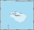
A tiny island
Asked by Peter from Brandon Orthopedic Associates on Feb 5, 2005.
when standing on the west coast of kauai, one can see an island to the north of niihau; what is the name of this island?
Answered by Paulo from the University of Hawaii on Feb 6, 2005.
Aloha, Peter. What you are seeing is Lehua island. It's a tiny island less than a mile north of Ni`ihau, and about 25 miles from Kauai. Lehua is actually the ridge of a sunken volcanic crater, and only a crescent-shape portion of the original volcano crater is visible. Lehua is popular with divers and fishers.