NOWRAMP
2002
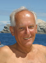
Dr.
Jim Maragos, U.S. Fish and Wildlife Service, Refuges Division
Posted by Mark Heckman
 Bio
brief: Dr. Maragos completed his Ph.D in Oceanography
at the University of Hawai‘i in 1972. He did his post
doctoral work on coral reefs at the University in 1973-1974.
Dr. Maragos spent the next 15 years, traveling and working
throughout the Pacific as the head of the environmental
office, Pacific Ocean Division for the U.S. Army Corps of
Engineers. He became the chief scientist for the Pacific
Region for the Nature Conservancy from 1991 to 1993, a Senior
Fellow at the East West Center in Honolulu until 1999. He
is now a Coral Reef Biologist for the U.S. Fish and Wildlife
Service. Dr. Maragos is one of the few experts on atoll
ecology in the world.
Bio
brief: Dr. Maragos completed his Ph.D in Oceanography
at the University of Hawai‘i in 1972. He did his post
doctoral work on coral reefs at the University in 1973-1974.
Dr. Maragos spent the next 15 years, traveling and working
throughout the Pacific as the head of the environmental
office, Pacific Ocean Division for the U.S. Army Corps of
Engineers. He became the chief scientist for the Pacific
Region for the Nature Conservancy from 1991 to 1993, a Senior
Fellow at the East West Center in Honolulu until 1999. He
is now a Coral Reef Biologist for the U.S. Fish and Wildlife
Service. Dr. Maragos is one of the few experts on atoll
ecology in the world.
You
are often noted as one of the primary forces behind the
NOWRAMP Expedition in 2000, which helped get the ball rolling.
What caused you to get involved?
"Well,
first of all, it was certainly not just me, many other folks
were pivotal as well. Rusty Brainard of the National Marine
Fisheries Service has been incredibly important, working
with us side by side. And we couldn't have done it without
the support of a variety of agencies and funding sources."
[In
2000 there were eight agencies and organizations involved,
the Hawai‘i Coral Reef Initiative/ University of Hawai`i,
U.S. Fish and Wildlife Service, NOAA's National Marine Fisheries
Service and National Ocean Service, Hawai`i Department of
Land and Natural Resources, Oceanic Institute, Bishop Museum,
and the University of California at Santa Cruz.]
"At
that time, I was working for the U.S. Fish and Wildlife
Service. Except for Kure, we have responsibility for 9 Northwestern
Hawaiian Islands as part of the Hawaiian Islands and Midway
National Wildlife Refuges, which stretch over 900 miles
and cover resources to 10 fathoms for most of the reefs
and islands, 20 fathoms for Necker Island and all reefs
at Midway. This is a vast amount of territory, and except
for a few efforts over the years, no broad surveys have
been done during the past two decades. These expeditions
allow us to understand areas that have not been previously
examined, to stimulate further research and funding, and
to assist in effective management. We need to know what
we have to work with."
Tell
us about that and the use of REAs or Rapid Ecological Assessments.
(Note - REAs involve quick inventories of plants, animals
on reefs or land habitats. Teams collect data at 3 sites
a day, trying to cover as much new territory as possible
with reasonable accuracy and include comparable rapid surveys
of cultural resources (shipwrecks, archeological sites,
etc.)
 "Well,
rapid ecological assessments are not new. We began using
them since the 80's in the main Hawaiian Islands, the Marshall
Islands, the Federated States of Micronesia, Palau, and
American Samoa. Procedures can vary according to what is
needed. When we did REAs for Palau, it was used to identify
candidates for the creation of a system of protected areas,
since only one existed at the time. Education was also a
key component. For the Northwestern Hawaiian Islands, the
protection is largely there, but we need more information
for effective direction of further research and management.
"Well,
rapid ecological assessments are not new. We began using
them since the 80's in the main Hawaiian Islands, the Marshall
Islands, the Federated States of Micronesia, Palau, and
American Samoa. Procedures can vary according to what is
needed. When we did REAs for Palau, it was used to identify
candidates for the creation of a system of protected areas,
since only one existed at the time. Education was also a
key component. For the Northwestern Hawaiian Islands, the
protection is largely there, but we need more information
for effective direction of further research and management.
"REAs
have also changed with the advent of new technology. In
the early years, we were creating atlases and inventory
reports. We did not have the computers, GPS (Global Positioning
System), digital videos, and so on that we have now. We
used aerial photos, in-water documentation and the best
maps we could find to create detailed atlases of the resources.
In the Marshalls for instance, we found that maps made for
World War II were very detailed and useful.
"Now
we have 2000 high
resolution satellite images, including multi-spectral
imagery. Each type of reef reflects light differently and
satellites can pick this up. This year we have a team (Daria
Siliciano and Marjo Vierros) who are doing this. We have
GPS information that allows us to be more accurate in mapping;
it can be entered on GIS (Geographical Information System)
software, to link information with precise locations of
field study sites. This all gets better each year as new
technology becomes available.
"For
the Northwestern Hawaiian Islands, the rapid ecological
assessments are critical. Seventy percent of all the coral
reefs in the United States are here in the Northwestern
Hawaiian Islands, and five times as much as in the main
Hawaiian Islands. We need to evaluate what the problems
or issues are here."
Do
some areas need more work than others?
"Some
have barely been looked at. Atolls like French
Frigate Shoals have the highest diversity of corals.
Should this get special attention? Are alien species already
in place at various sites or are reefs still pristine? What
sites need the most protection from alien species? If we
do not look we will not know. Rapid ecological assessments
help with all of these questions."
How
is this trip different for you that the 2000 voyage?
"First
of all, we have a new partner this year. The federal Northwestern
Hawaiian Islands Coral Reef Ecosytem Reserve was created
in 2000 by presidential executive order and the managers
for the Reserve have an important role and are sponsoring
much of the present expedition.
"The
REAs result in collecting more in situ (on site) information.
We have an additional person for the algal team and but
still have only one coral person on each team. And we are
surveying the reef areas we missed the first time. There
are many more areas to do. And, of course, we have the multi-spectral
and satellite imaging. One of my team (Daria) is doing coral
cores to provide a historical perspective on local growth
rates and temperatures. And we are setting up permanent
transects or resurveying transects on all 10 islands.
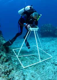
"A
number of 50-meter long permanent transects allow us to
collect different information than collected by the REAs.
We set up stainless steel stakes every five meters so that
we can relocate the transects in future years and begin
to monitor change over time, using corals as our key indicators.
We can get back to the exact same place, the same coral
heads, and track their health over a range of years."
How did you get involved in atoll ecology?
"Spending time in the ocean when I was a kid. In high
school I had a chance to read about soil and forest conservation
in the US and was concerned about their loss over the previous
century. And I lived in Long Beach, California, so the ocean
was there. I read Rachel Carson's The Sea Around Us. That
influenced me. Then in college, I read a pamphlet on atolls
that one of my professors at UCLA wrote, and it fascinated
me. Now here I am, nearly 40 years later, having studied
40 - 50 atolls and I feel priviledged to be knowledgeable
about them."
What is important to you?
"In
the late 60's I was one of the people doing research on
Kaneohe Bay, on Oahu, Hawai‘i. At that time it had
a sewage outfall pipe emptying into the shallow southern
bay and it was a mess. Our research helped get that outfall
removed and help bring the bay back to a more healthy condition.
I feel fortunate to have been to be involved in that.
"It
seems to me that over the last 500 hundred years we have
lost track of our connections to the natural world. Bob
Johannes, a great scientist, encouraged me to apply research
to help to solve real problems, not just add a bit of esoteric
information. We are on earth just a short time. I think
this is the direction we all need to follow to some degree.
We are all part of the Earth's ecosystem."
 Mark
Heckman
Mark
Heckman