|
You
are here: /main/research
expeditions/July 2007/Journal
Day 4
Journal
Day 4
by Keeley Belva
Click
here to see where the Hi'ialakai is now.
Click
here to see current data from the ship.
Looking out from the ship this morning, as I drink my coffee
on the stern of the main deck, all I see is water in every
direction. Disappeared is Nihoa, the highest island
of the Northwestern Hawaiian Islands chain, where we spent
the last day and a half working on the various research projects. Today
is Day 4 of the research cruise to Papahānaumokuākea Marine
National Monument aboard NOAA Ship Hi`ialakai and
we are transiting today between Nihoa and Gardner Pinnacles,
but to find exactly where we are I have to go to NOAA’s
Ship Tracker website.
In the last couple of days of dive operations, we have been
able “shake down” the plans for data collection. There
are three small boats that are being used to transport each
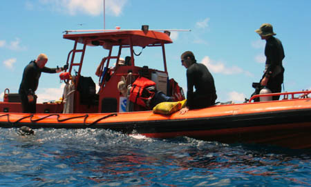
of the research teams. HI-1 has been transporting the “fish
team,” the researchers that are collecting DNA on several
species of fish to learn more about the genetic connection
of the populations. The algae team and the invertebrate
team are aboard HI-2, and the mapping team is on HI-6, a
small, hard bottom zodiac.

Researchers on the “fish team” aboard
HI-1 following a dive. Credit: Keeley Belva
 So far, I have been able to spend time aboard both HI-1
and HI-2, learning more about their projects. And since
I’m not diving on this trip, it has been an opportunity
to contemplate life above the surface at Nihoa, while listening
to the myriad of birds flying overhead. Archeologists
have determined that this island did sustain Native Hawaiians
for some period of time in the past. From Adam’s
Bay on the south side of the island, there are indications
of these early residents—terraced platforms that may
have been heiau and cutouts in the rock could have been used
for shelter. One thing you don’t see much evidence
of is fresh water, yet from my view on the boat I can see
the entire world population of the loulu or Nihoa Fan Palm
(Pritchardia remota), an endangered species that
obviously gets water from somewhere. So far, I have been able to spend time aboard both HI-1
and HI-2, learning more about their projects. And since
I’m not diving on this trip, it has been an opportunity
to contemplate life above the surface at Nihoa, while listening
to the myriad of birds flying overhead. Archeologists
have determined that this island did sustain Native Hawaiians
for some period of time in the past. From Adam’s
Bay on the south side of the island, there are indications
of these early residents—terraced platforms that may
have been heiau and cutouts in the rock could have been used
for shelter. One thing you don’t see much evidence
of is fresh water, yet from my view on the boat I can see
the entire world population of the loulu or Nihoa Fan Palm
(Pritchardia remota), an endangered species that
obviously gets water from somewhere.
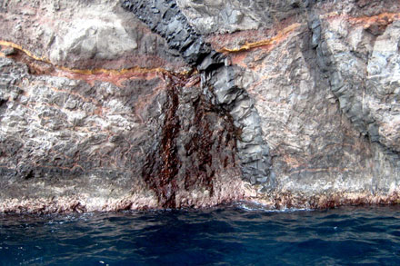
At our next site on the west side of the island, the
view is completely different. The sheer cliffs meeting
the water make it look as if we are seeing another island. As
the divers descend to the bottom, those of us on the boat
see a freshwater seep coming from the rock wall—proof
that there is a water source on the island. You can
also see the geological history of the island in the striations
of the rock.

Without surface streams or ponds on
Nihoa, archaeologists have speculated that Native Hawaiians
were dependent on rainfall, and perhaps springs or seeps,
to provide them with drinking water. The vertical
discolored area in the center of the photo is freshwater
trickling into the ocean. The
rock structures at the source of the seep are a classic intrusive
dike (vertical) crossed by a horizontal sill, the exact structures
that one would predict to hold freshwater. The density
of the intrusive lava (relative to the flows around it) prevents
the groundwater from migrating horizontally or percolating
vertically into the subaerial/submarine portions of the island's
water table. Credit: Randy Kosaki
Now far from “bird island,” the vast blue now
surrounding the ship gives us time to prepare ourselves and
our equipment for the next stop at Gardner Pinnacles—still
somewhere in the horizon waiting for our arrival tomorrow
morning.

Sailing off into the sunset, last
views of Nihoa before making our way to Gardner Pinnacles.
Credit: Randy Kosaki
Click
here for maps of the region
|