You
are here: /main/research
expeditions/June-July 2006/Photo
Gallery_1
Photo
Gallery
Next >>
Days 1-4: Research Preparations While in Transit

The abundance of fish in a healthy coral reef ecosystem are part of what
makes the Northwestern Hawaiian Islands so special.
Photo: James Watt
|

Members of the NOAA Maritime Heritage Program will be surveying some of
the world's most beautiful and untouched submerged cultural resources
during this expedition.
Photo: Robert Schwemmer/NOAA
|

The NOAA ship Hi'ialakai will be supporting a multidisciplinary
research
expedition which includes a benthic habitat mapping team, maritime
archaeologists and interpretation of this research through education and
outreach specialists. Photo: NOAA
|

Ellyn Tong,
Hawai`i Audubon Society
|

Ship crew and the scientific party participate in an abandon ship drill, which occurs on every research cruise.
Photo: Claire Johnson/NOAA
|
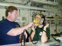
The maritime heritage team dons agamasks in the dry lab to get practice in using their new underwater communication system.
Photo: Claire Johnson/NOAA
|
A mock shipwreck survey takes place on the stern of the ship to demonstrate research techniques that will be used underwater.
Photo: Paulo Maurin
|

Co-chief scientist Hans Van Tilburg collects mock data while running through baseline trilateration exercise with his underwater archaeology team.
Photo: Claire Johnson/NOAA
|

Co-chief scientist Hans Van Tilburg demonstrates baseline trilateration as the education team attentively observes.
Photo: Paulo Maurin
|

The deck crew discusses small boat safety to prepare the science party for being launched overboard from the ship to conduct their research.
Photo: Claire Johnson/NOAA
|
Day 4: A GIS Perspective

Members of the mapping team work through the night in a small computer lab with numerous screens.
Photo: Claire Johnson/NOAA
|

A few ships have conducted high-resolution seafloor mapping in the Northwestern Hawaiian Islands as shown in the colorful
track lines.
|

Chief Scientist Dr. John Rooney points out the tracks that have been mapped around Kure Atoll.
|
Day 4-6: Trilateration in Maritime Archaeology

Maritime Archaeology Team members: Dr. Kelly Gleason, Lindsey Thomas, Dr. Hans Van Tilburg, Tane Casserley, Robert Schwemmer, Brenda Altmeier. Photo: Paulo Maurin |

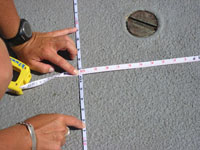
Maritime archaeologists train by measuring objects
on the ships deck. Photo: Paulo Maurin |

Student map of a shipwreck off Lanai, Hawai`i. Credit: University of Hawai`i Marine Option Program |

Sketch showing trilateration of an object on deck using a baseline. Photo: Paulo Maurin
|
Next >>
|