|
You
are here: /main/research
expeditions/June-July
2006/Overview
June-July
2006 Mission Overview and Objectives
By Claire Johnson,
National Education Liaison NOAA National Marine
Sanctuaries
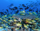
From June 23 through July 20, 2006, a multidisciplinary team
of scientists, archaeologists and educators will explore the Northwestern
Hawaiian Islands. The mapping team is made up of oceanographers, coastal
geologists, geographic information system specialists, and seafloor
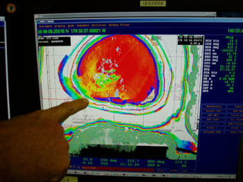
video analysts. The mapping team will operate one of two multi-beam
mapping systems installed on the ship to generate high-resolution bathymetric
data and acoustic backscatter imagery. This technology provides information
about the composition of the seafloor, such as whether the bottom is
rocky or sandy. These very detailed and accurate map products help
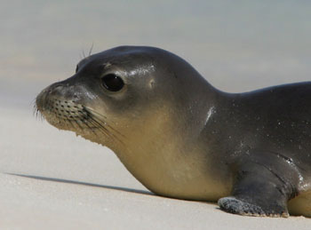
to delineate habitat suitable for corals, fish, endangered Hawaiian
monk seals and other organisms inhabiting the atolls. The mapping research
has proven to be a critical tool for marine resource managers and scientists.
In addition to shipboard mapping work being conducted day and night,
the 25-ft survey launch, the R/V AHI is also equipped with a multi-beam
system and will be launched each morning to map shallower portions
of the atolls, where it is unsafe to navigate the larger research vessel.

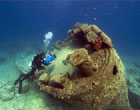
Members of the NOAA Maritime Heritage Program will be surveying some of the world's most beautiful and untouched submerged cultural resources during this expedition.
Photo:
Robert Schwemmer/NOAA
The
team of six maritime archaeologists from the NOAA Maritime
Heritage Program will conduct underwater archaeological
surveys at several shipwreck sites at Kure Atoll and Pearl
and Hermes Atoll. The teams work at Pearl and Hermes Atoll will, in addition to several other tasks, continue work on the whaling shipwrecks discovered at this atoll in 2004 and thought to be the underwater archaeological remains of the whale ships Pearl and Hermes, for which these atolls were named. Work at Kure Atoll will include returning to the site of the USS Saginaw, discovered in 2003 and an amazing story of survival at sea, as well as further survey of an unidentified 19th century whaling shipwreck thought to be the Parker. The Northwestern Hawaiian Islands contain some of the worlds most beautiful and untouched submerged cultural resources and the opportunity for the team to survey these sites in 2006 will allow scientists to bring these remote shipwreck sites to the public.
The
education and outreach team will work with all of the scientists
and crew aboard the NOAA ship to interpret this exciting
research as well as broaden interpretation of the region
in general for a diverse audience through several established
mechanisms. Data collected on this research cruise and
other cruises aboard the NOAA ship Hiialakai help
to make important management decisions in support of the
Northwestern
Hawaiian Islands Marine National Monument, State
Marine Refuge and the Hawaiian Islands National Wildlife
Refuge.
Understanding the near-pristine marine environment and
valuable heritage resources of the Northwestern Hawaiian
Island atolls is an important step towards generating stewardship
and inspiring an interest in conserving this ocean wilderness
for future generations. Scientists aboard the vessel in
June and July 2006 will work to interpret and deliver this
message to the public.
|