|
You
are here: /main/research
expeditions/ 2005 RAMP/9_21_05
Mapping
9/21/05
- Mapping
by
David Nichols, State of Hawaii, DLNR, HIHWNMS
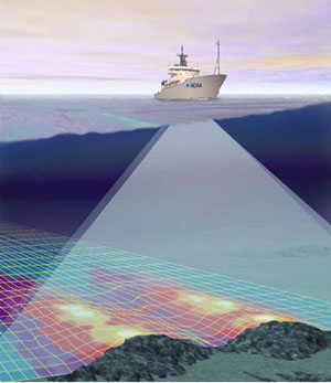
Graphical representation of a multi-beam system at
work mapping the ocean floor.
There was a full day of activity at Maro Reef today. The Rapid
Ecological Assessment (REA) teams continued their monitoring
of the species composition, abundance, percent cover, size
distribution, and general health of the fish, corals, other
invertebrates, and algae of the coral reef. The collection
teams continued to collect specimens of reef fishes and invertebrates
for characterization of genetic diversity and connectivity
to better understand biological linkages supporting and maintaining
these island/atoll ecosystems. The apex predator team recovered,
downloaded, and redeployed receivers set in May-June 2005
to recover data on detections of fishes tagged with transmitters.
In addition to assessment and monitoring of the biological
component of the coral reef ecosystem, the NOAA Ship Hi`ialakai
is also equipped to perform multibeam mapping. While the research
scientists are busy analyzing the data and sorting specimens
following their day in the water, the survey technician is
just starting his day. HI’IALAKAI Crewmember Jeremy
Taylor is currently responsible for making sure the insanely
complicated multibeam mapping system onboard does its thing
- map the ocean floor.
First
it is necessary to launch a CTD instrument into the water
that will continuously provide information on the conductivity
(salinity) and temperature at various depths. This is necessary
in order for the sonar mapping system to calibrate correctly.
Sound travels differently at differing salinities, temperatures,
and densities. All this information gets computed as the ship’s
sonar passes over the sea floor. The result is a very picturesque
three-dimensional output of the ocean bottom illustrating
features such as canyons and pinnacles.
At
any given moment there is much activity aboard the ship. Activity
focused at maximizing the scientific information gathered
from this spectacular underwater landscape.
Return
to Expedition main page
|